UAV (Unmanned Aerial Vehicle) photography and photogrammetry has long been a balance between weight and the quality of the camera equipment carried.
Cameras
Low cost camera solutions such as the GoPro can be carried on almost all UAVs because they are small and lightweight, but these benefits are also drawbacks because limited size/fish eye lenses and small image sensors reduce the quality of the photographs they take, together with this the lack of control of many of the camera settings is a drawback.
High quality DSLR (Digital Single Lens Reflex) cameras have superior quality lenses and image sensors together with the fact that they have extensive control of the camera settings meaning that they take much better photographs. But they can only be carried by much higher power/cost octo and hexo-copter systems.
One solution is the lightweight point-and-shoot camera/compact camera used in some mapping solutions, such as those provided by 3DRobotics (Canon PowerShot S100). Although these cameras provide a better quality solution than the GoPro, and may be all that is required for mapping exercises; they are still limited in their optics and higher megapixel sensors which are much more important in the recording of complicated structures and photogrammetry work.
Changes in the camera industry due to competition from the phone industry has enhanced development of a different solution. This is the MILC (Mirrorless Interchangeable-lens camera) or DSLM (Digital Single Lens Mirrorless) Camera. These cameras don’t have the mirror reflex optical viewfinder of a DSLR camera, and the associated weight, replacing it with a LCD screen or with an app on a mobile device which controls the camera. As a result they have the capability to carry high quality interchangeable lenses without the weight associated with DSLR cameras. The system comes in two different forms; the first resembles a standard digital SLR camera, while the second resembles just a lens with all control being provided by an app on a mobile device.
Gimabls are an important element in stabilizing cameras during photography and video recording, as well as providing a motorized solution to move the camera to a desired angle during flight. They can add significantly to both the weight and price of any UAV solution depending on the camera equipment they are carrying.
The 3DRobotics Iris+ Quadcopter has a payload capacity of 400g which would allow a rather small 15g for a mount to attach a Sony A5000 DSLM or 68g to attach a Sony QX1 Lens-Style Camera without weighing too much, although the system could be flown with excess weight reducing the flight time. A downward facing 3D Printed Sony A5000 Mapping Mount is available for both the Iris+ Quadcopter and X8+ Octocopter, it weighs 36g.
Sony α5000 Mount
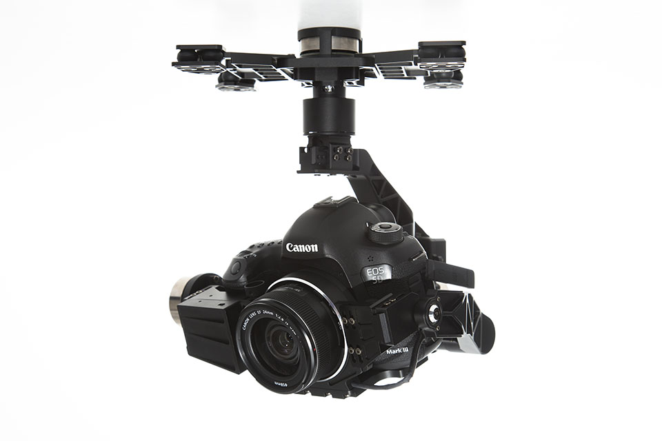
Although the X8+ is a octocopter by definition, it gets over the intrinsic problems of size, weight and cost caused by eight separate arms by having two rotors on each arm, one pointing up and the other downwards. With a maximum payload of 1KG it can carry a Sony A5000 DSLM camera (388g) together with a gimbal such as the DYS 3 Axis Brushless Gimbal for Sony NEX size cameras (609g) to support and move it, the gimbal is designed for the NEX range of cameras, but they are almost identical to the A5000 in design. Although a lighter mount could be used.
3 Axis Brushless Gimbal for Sony Nex size cameras
Conclusions
The mirror-less camera would seem to provide a solution to the problem of how to carry a high specification camera capable of capturing high quality images on a fairly low-cost UAV solution.
Recent developments in a number of technical areas has allowed the development of battery powered UAV (Unmanned Aerial Vehicles) systems which has allowed recording technologies to become airborne easily with extensive control over what is being recorded.
Many of these low cost UAV solution come ready to fly out of the box with some even coming with a camera. These systems have allowed archaeology and cultural heritage to be recorded in whole new innovative ways.
There are basically two types of UAV systems that are employed, each with their benefits and drawbacks:
Fixed wing systems use less power and can spend longer flying, but don’t have the ability to hover in one place or change direction quickly. They are also designed for mapping so carry cameras that only point downwards.
The 3DRobitics Aero-M fixed-wing drone
Multi-rotor systems use more power as their multiple rotors are turning all of the time they are in the air, so they can spend less time flying and recording. They have the ability to hover and change direction and altitude quickly.
The 3DRobotics X8-M hexacopter
Recent developments have seen UAVs which combine the two systems, such as the SkyProwler Kickstarter Project. This is a system that can be fixed wing, fixed wing with rotors or just rotors. The rotors are retractable which can be deployed when required while in the fixed wing configuration.
Krossblade SkyProwler
UAV Technological developments
A number of technological developments have led to the recent proliferation of UAV systems being used in different industries and hobbies.
Batteries
The development of the LiPo (Lithium Polymer) battery brought a number of improvements over the previous NiMH (Nickel-metal hydride) battery technology used in Radio Control (RC) Vehicles. They:
Have a larger capacity and last longer.
Are more powerful.
Are smaller and lighter.
Are cheaper.
This means that a UAV system can fly for longer, further and faster with a battery that weighs less.
Brushless Motors
The brushless motor has taken over from the brushed motor in the RC (Radio Control) industry with their:
Superior power.
Higher efficiency.
Greater reliability.
Higher accuracy.
Reduced noise.
Lower susceptibility to mechanical wear.
Longer lifetime.
Smaller size.
A brushed motor works by controlling the polarity of an electromagnet (coil of wires) between two magnets of different poles. The brushes in the brushed motor carry the electric current to the armature (electromagnet) of the motor by being in constant contact with it as it rotates. This causes wear to the brushes and at higher speeds friction, reducing torque and creating heat.
The brushed motor works in the opposite way, by having the coils of wire on the outside, with the magnet in the middle. It removes the need of the brushes but complicates the process as the position of the rotor needs to be sensed and the coils controlled in phase by an electronic speed controller (ESC). Although they are mechanically more complicated and cost more than brushed motors, their other benefits outweigh those of the brushed motor.
Linked intrinsically with the Brushless Motor is the Brushless Gimbal, this is a system which both; holds a camera steadily and level in a single position while the UAV moves around it thereby removing camera shake, and it also can be panned up and down and side to side in more expensive systems.
2-axis. This has two brushless motors which control the camera pitch and roll. This system relies upon filming in the direction that the UAV is pointing and is generally available on the cheaper UAV systems. These have legs which would be in the way if the camera was able to yaw.
DJI Zenmuse H3-2D Gimbal
3-axis. This has three brushless motors which control the camera pitch, yaw and roll. This allows cinematography to be conducted from UAV platform with the movement of the camera almost completely removed from the movement of the UAV. And in many cases a separate person can control the camera. These more expensive systems generally have retractable legs allowing the camera to pan left and right.
DJI Zenmuse Z15-5D III (HD) Gimbal
Gimbals can also be constructed using technology and how-to guides readily available on the internet. A number of Brushless Gimbal Controler Boards are available (including the V3 Martinez Board) as well as gimbal kits and brushless motors.
V3 Martinez Brushless Gimbal Controller Board
GPS (Global Positioning System)
GPS has a number of applications within the UAV industry:
It is used to make flight easier by using the GPS signal to hold the UAV in one place by calculating if it is moving.
It can be used together with an autopilot to automatically control the flight path of the system.
The GPS co-ordinates at which each photograph is taken can be used within photogrammetry software to help with the locating and aligning of the photographs.
3DR uBlox GPS with Compass
Mast
The GoPro
The lightweight GoPro series of camera was another enabling factor in the development of the UAV market. Many UAVs are in fact developed with the GoPro camera in mind. Not only are the GoPro series of cameras a lightweight powerful system but they also have wireless communication allowing the camera to be controlled, and the display to be viewed remotely.
Although there are now a number of different sports cameras the majority of low cost UAV systems, particularly those on the Kickstarter and Indiegogo crowdfunding platforms are designed with carrying the GoPro in mind.
Autopilot Systems
Autopilot systems can be very beneficial in the recording of different aspects of Archaeology and Cultural Heritage.
They can be used to plan a flight path for the UAV to take over the subject matter.
They can be used to create a grid pattern flight path as part of a mapping operation.
Setting a flight path within Autopilot software
3DRobotics
3DRobtics is a personal drone manufacturing company which also manufactures open source autopilot systems that are the most popular in the world. They are used on many of the Kickstarter systems available.
The company produce two Autopilot systems:
The APM 2.6 System is based on the Arduino micro controller. It includes a 3-axis gyro, 6 DoF (Degree of Freedom) accelerometer, high-performance barometric pressure sensor and automatic datalogging.
APM 2.6 Autopilot
The Pixhawk is an advanced autopilot system designed by the PX4 open-hardware project and manufactured by 3D Robotics, it includes a 3-axis 16-bit gyroscope, 3-axis 14-bit accelerometer/magnetometer, 3-axis accelerometer/gyroscope and a barometer. A digital airspeed sensor and GPS and compass can be purchased with the system and plugged into the Pixhawk board.
Pixhawk Autopilot
NAVIO
The NAVIO is an Indigogo project to build a Raspberry Pi based autopilot which attaches to the top of the credit-card sized computer allowing the construction and control of a UAV system with the powerful small computer system.
NAVIO Autopilot
Follow Me Technology
A recently developed technology which is becoming increasingly popular in the drone industry is the ‘Follow Me’ technology where the drone will follow some sort of controller, whether a mobile phone / tablet / laptop or a specially designed piece of technology such as the AirLeash which comes with the AirDog drone. These systems use autopilots systems combined with GPS technology in the controller to control the direction and speed of the UAV system.
The ‘Follow Me’ technology is designed for the extreme sports industry where the drone can follow the user, filming as it flies, whether they are on a motorbike/mountain bike, surf board or other sports equipment. As well as controlling the flight path of the drone following the user it also controls the gimbal that holds the camera keeping the user in shot at all times. In some systems a number of pre-determined video filming techniques are made available with the control app which add to the abilities of the system.
Within Archaeology and Cultural Heritage the system has the potential for filming site tours, where the person giving the tour is tracked by the ‘Follow Me’ system, they would also have a digital audio recording system attached to them to record the dialogue which could be matched with the video in post-production. It would allow one person to do all of the production of the video.
Object tracking and following
Object tracking and following is an expansion of the ‘Follow Me’ technology where rather than following a GPS enabled device an object is selected within an interface and the system visually tracks the object. The UAV follows the tracked object with the camera being locked onto it.
Shift
The Shift has been developed by Perceptiv Labs, it attaches to existing UAV systems, such as those designed by DJI and 3DRobotics, as well as custom systems created with a number of different flight control systems and autopilot systems.
Shift Object Tracking System
Through the use of a Shift Eye video camera (attached to the camera of the UAV system) and a Shift Processor computer which plugs into the autopilot it provides standard UAV systems with the ability to track up to four subjects and follow and record them in flight. The subjects are selected using an app available on Android devices.
This could add to the site tours potential of the ‘Follow Me’ technology by selection the tour guide within the app when they are walking around, then also selecting the area under study when appropriate. This would be done best by having a second person controlling the app by watching the video, selecting the areas of interest when required and moving back to the tour guide when needed.
Autonomous
Development in autonomous flight of UAVs has a number of benefits for recording where a UAV could record the progress of an excavation at intervals, or record a standing building without any need for control by the pilot.
A number of simple autonomous technologies have already been integrated within commercial UAV technology.
Ultrasonic distance sensors
Ultrasonic distance sensors calculate distance by sending an ultrasonic wave and calculating the time it takes to receive the wave back.
MB1240 XL-MaxSonar®-EZ4™ High Performance Ultrasonic Range Finder
They can be used in obstacle avoidance systems for UAVs, with the ultrasonic beam bouncing off objects in the UAVs path. The ultrasonic sensor is attached to the autopilot which can alter the path of the UAV when an obstacle is detected. With the APM autopilot the sensor it is enabled and calibrated within the Mission Planner Software.
Optical Flow Technology
Optical flow technology is a technique where multiple images from a sensor are compared to determine movement, recent developments in technology mean that this can now be done in real time. It can be used in combination with Autopilot systems to stabilise the flight position of a UAV by detecting movement between photograph and altering the flight accordingly.
The PlexiDrone Indiegogo crowfunding project even comes with the technology demonstrating the growing availability and cheapness of the technology.
The Parrot Bebop Drone comes with Optical Flow Technology integrated into its design (8), with an image of the ground being taken every 16 milliseconds and then compared with the previous one.
Plexidrone
The PlexiDrone Indiegogo crowfunding project also comes with the technology demonstrating the growing availability and cheapness of the technology in crowdfunding projects.
As well as being integrated into in some UAV technology the sensors themselves can be purchased separately; in UAV technology they come in two distinct types:
Mouse Based. The mouse based sensor is based upon the technology of optical computer mice.
3DRobotics Optical Flow Sensor Board with ADNS3080 mouse sensor
CMOS Based. The CMOS based sensor uses a CMOS camera chip to capture the images.
3DRobotics PX4FLOW KIT with MT9V034 machine vision CMOS sensor with global shutter
Vision Positioning System
The Vision Positioning System present in the DJI Inspire 1 uses a combination of Ultrasonic sensors and Optical Flow Technology to control the position of the UAV in environments where GPS signals cannot reach. It can hold its position and stop when the RC controls are released.
DJI Inspire 1 Vision Positioning System – [1] Two sonar sensors [2] One binocular camera.
Intel RealSense
The Intel RealSense is a new depth-capturing camera technology designed to be incorporated into the latest laptop and tablet technology. It has the ability, thanks to its specialised lens array, to alter the focus of photographs after they have been taken, like the Lytro Illum. It can also track hand gestures to control the computer systems and 3D scan real world objects.
The new Astech Trinity Autopilot system incorporates 6 Intel RealSense cameras enabling 360˚ motion capture and obstacle avoidance .
The Astech Trinity Autopilot will be incorporated into the AscTec Firefly later this year.
A lot of technical development has gone into the idea of drone swarms where multiples drones fly together in cooperation. Amongst the applications considered for their use are search and rescue, crop pollination, surveillance, monitoring traffic and as a distributed computing and communications network in disaster areas. Work at the GRASP (General Robotics, Automation, Sensing & Perception) Lab at the University of Pennsylvania has included navigating obstacles, Simultaneous Localization and Mapping (SLAM) using a Microsoft Kinnect and Laser Rangefinder, flying formation by monitoring each other’s position and co-operation in building structures.
Within Archaeological and Cultural Heritage recording this has the potential for a swarm of UAVs to record areas in co-operation reducing the time taken, as well as the potential of using different technologies to record at the same time.
Recording Technologies
Introduction
A UAV can act as a platform for a number of different recording technologies that can be employed in the recording of Archaeology and Cultural Heritage.
Photogrammetry
Photogrammetry is a technique for taking measurements from photographs and can be used to create a number of different results.
The type of camera system used depends on the type of UAV system employed, the more powerful the system the heavier and more powerful the camera that it can carry.
Weight is an important consideration; cheaper UAV systems are designed to only carry the GoPro or another extreme sports camera. While the more expensive/powerful systems can carry higher powered digital SLR cameras which record in much higher levels of detail and without lens distortion. The better quality the camera the more details are recorded.
A number of 360° camera systems have been released which can be attached to the bottom of UAV systems. These have the potential to record many more photos than a single camera, this could potentially speed up photogramemtric recording as well as providing immersive experiences using VR (Virtual Reality) technology such as the Oculus Rift.
360Heros 360° GoPro mount
Archaeological Mapping
UAVs are used for mapping within a number of industries, and have already begun to be used in the mapping of archaeological sites. They provide an ideal platform for the creation of DTM (Digital Terrain Model) and DSM (Digital Surface Model) models which can be used in GIS (Geographical Information Systems) applications.
This is the ideal project for a fixed wing UAV which can be deployed to fly over the area under study with a downward facing camera. The major benefits of such a systems is the stability, the amount of time that they can fly and hence the amount of recording that they can do in one flight.
Using autopilot systems and software for programming the autopilot, such as Mission Planner, the flight plan for the UAV can be programmed.
Setting out a UAV light pattern in the Mission Planner Software
Such software has the ability to create a grid flight pattern using the study area selected in the map interface, the altitude flown, the image overlap and the characteristics of the camera being used. Any alteration in the altitude, image overlap or camera specification (such as lens used) will alter the grid pattern to accommodate the alterations.
Setting out a grid UAV flight pattern in the Mission Planner software
A grid of circular paper targets can be set up on the ground with each target being surveyed in using a GPS (Global Positioning System) which both increased the accuracy of the photogrammetry model and georeferences the results so they can incorporated with other data within a GIS system
Standing Building Recording
Photogrammetry has a long history in standing building recording which has be enhanced by the ability of the Total Station to survey points accurately. Limitations of ground based photogrammetry include the ability to record information high above the ground or masked from view. Traditionally this has been solved by using scaffolding, but his is an expensive and time consuming system which can also be dangerous.
Another option is to use standard building photogrammetric recording techniques to record structures in high detail using a UAV to fly the camera at set heights parallel to the structure. This would mean that high quality imagery could be created using standard methods. The UAV can act as a mobile camera platform/tripod which has the ability to take to camera to heights not easily accessible by other means. Certain points on the building surface would need surveying in using a total station to georeference the 3D model created by the photogrammetry process and to make it more accurate. Orthophotos (geometrically corrected images) can be created from the images taken which are an important element in building recording.
Increasing development in autonomous flight can be used to automate the flight patterns having the UAV automatically record buildings.
HDR (High Dynamic Range)
High Dynamic Range photography is a technique where multiple images are taken with different exposures (bracketing), these are then merged together using computer software to form an image with all of the detail from the images. Many modern digital camera have an auto-exposure bracketing (AEB) setting which allows this to set up on the camera to be done automatically. There are also dedicated HDR cameras. It provides images which are close to what the human eye can see and with more information than standard photographs.
The problem with using UAVs for this technology is that the images need to be taken while the camera is perfectly still, and even with a camera gimbal a UAV is likely to move slightly between the photographs being taken.
HDR photographs can also be used in photogrammetry.
Video
The video capabilities of most cameras that UAVs carry mean that they can record videos. As we have already seen the ‘Follow-Me’ technology has the potential within archaeology or cultural heritage to record a site tour, filming the tour guide as they walk around site, with a separate digital recording system recording the audio which can later be combined with the video footage in post-production. The Hexo+ UAV Director’s Toolkit allows different filming scenarios such as crane; pan, tilt, crab, dolly, 360° around you, and far-to-close/close-to-far.
The UAV has the potential to create immersive fly through videos of sites thanks to the recent introduction of multi-camera systems or systems with multi-lens cameras, this can aid in public interaction and interest.
Archaeological Prospection
Lidar (Light Detection And Ranging)
LIDAR is a technology which has already proved useful in Archaeology and Cultural Heritage, it works by firing a pulsed laser beam at the ground and recording the returned beams, the time it takes for the beam to return is recorded and this is used to determine the distance. It is tied to the flight instruments of the light aircraft carrying the LIDAR and accurately records the 3D position and height of the results creating a dense point-cloud of the topography being recorded. The resulting LIDAR point data can be loaded in GIS systems.
It has the potential to discover archaeological remain under woodland by removing points from the LIDAR point-cloud leaving only the points that hit the ground between the forest cover.
Although not a cheap technology a number of LIDAR systems have recently been developed which can be carried as a payload on UAV systems. This includes the Phoenix Aerial Systems AL3 S1000 Copter which combines a DJI S1000 Octocopter with their AL3 technology which includes the Velodyne HDL-32 high definition LiDAR sensor.
Phoenix Aerial Systme – AL3 S1000 Copter
If the UAV system recorded high quality photographs as well, these could be recorded in a separate flight using the same flight path, these could be used to overlay the LIDAR data.
LIDAR can be analysed with a number of computer tools enabling more information to be visualised.
LiDAR Data with Multiple Hillshades and with Principal Component Analysis (PCA).
Multi-Spectral and Hyper-Spectral Imaging
Multi-Spectral and Hyper-Spectral imaging involves the recording of the electromagnetic spectrum outside the visible spectrum, this includes the infrared which can detect differences in ground moisture helping to determine what is below the ground level.
Traditionally this has been done using satellites but spectral imagers are also available for UAV platforms.
Ground Penetrating Radar is a technology that is used within field archaeology to discover buried features, it works by recording reflected radio waves that have been transmitted into the ground. GPR can be used on areas such as concrete, stone and tarmac where other geophysical techniques won’t work.
MSc students from the University of Southampton carrying out a GPR survey in the vicinity of the Episcopio, between Portus and the Isola Sacra, Italy (https://kdstrutt.wordpress.com)
The potential of having UAVs carry Ground Penetrating Radar recording equipment has already been tested in a number of fields including the detection of IEDs (Improvised Explosive Devices) and mines and the characterization of soil properties. But studies, including one at the University of Leicester, are looking into the potential of GPR carrying UAVs in archaeological recording.
Bibliography
Amiri, Amin, Kenneth Tong, and Kevin Chetty. “Feasibility study of multi-frequency Ground Penetrating Radar for rotary UAV platforms.” (2012): 92-92.
Jacobs, Axel. “High dynamic range imaging and its application in building research.” Advances in building energy research 1, no. 1 (2007): 177-202.
Li, Zhe, Yan Li, and Nankai Tian Jin. “Photogrammetric recording of ancient buildings by using unmanned helicopters-cases in China.” International Archives of the Photogrammetry, Remote (2011).
Michael, Nathan, Shaojie Shen, Kartik Mohta, Yash Mulgaonkar, Vijay Kumar, Keiji Nagatani, Yoshito Okada et al. “Collaborative mapping of an earthquake‐damaged building via ground and aerial robots.” Journal of Field Robotics 29, no. 5 (2012): 832-841.
Ntregkaa, A., A. Georgopoulosa, and M. Santana Quinterob. “Photogrammetric Exploitation of HDR Images for Cultural Heritage Documentation.” ISPRS Annals of the Photogrammetry, Remote Sensing and Spatial Information Sciences 5 (2013): W1.
Saleri, Renato, Nocerino Erica, Fabio Remondino, and Fabio Menna. “ACCURACY AND BLOCK DEFORMATION ANALYSIS IN AUTOMATIC UAV AND TERRESTRIAL PHOTOGRAMMETRY-LESSON LEARNT.” In International Archives of the Photogrammetry, Remote Sensing and Spatial Information Sciences, vol. 2, pp. 203-208. 2013.
With the change in the way that projects are funded a number of drone/UAV (Unmanned Aerial Vehicle) systems have been funded on Kickstarter, these systems are generally designed to fill a perceived gap in the market providing everything from wildlife conservation to tornado research.
A number of these have innovative technologies which can aid in the recording of archaeology/cultural heritage.
This blog entry will be an evaluation/comparison of these various systems, charting their speifications and abilities to help with archaeological and cultural heritage recording.
Conclusions
The obvious conclusion can be drawn that the GoPro camera is the single most popular camera for use with UAVs due to its size and capabilities. But of equal popularity is the series of open source autopilot systems designed by 3D Robotics (APM and Pixhawk), this demonstrates the quality and abilities of these products.
It could be suggested that the bubble has at least partially burst on the funding of UAV (Unmanned Aerial Vehicle) projects on Kickstarter from the number of new projects that have failed to reach their funding goal recently. Although some Kickstarter projects are probably not funded due to the fact that they bring nothing new to the area of UAVs, some others appear to have innovative ideas and still receive little funding.
The potential of autopilot follow-me technology for the recording of site tours has been discussed in the reviews of the AirDog and HEXO+ systems. The swarm capabilities of the ZANO system brings forward the possibility of multiple UAV systems recording the subject matter from multiple different angles at the same time allowing the recording of significantly more visual data than a single UAV.
New developments have been used to control the position of the done and the ability to avoid obstacles including ultrasonic distance measurement.
The micro and nano drone systems provide a means of recording a subject with systems that, in one case can fit in a pocket and otherwise, can be easily portable and taken to the subject that requires recording, even recording tight shaft trenches with a system that has ultrasonic distance detection technology keeping the system away from the edges of the metal sheet piles.
The PlexiDrone is an Indiegogo drone project aimed at film makers and aerial photographers.
The system comes in two different configurations; the x4 has four rotors while the x8 has 8, four above and four below. As a result they have different flight characteristics.
Flight time – 25 mins x4, 20 mins x8
Speed – 37 mph x4, 42mph x8
Thrust – 2.35 kg x4, 4.1 kg x8
It’s other specifications include:
Follow me technology
Retractable landing gear allowing an unobstructed view below the drone enabling a 360˚ camera gimbal
SwarmTech allowing multiple drones to be controlled and film the same subject matter
Object avoidance using ultrasonic sensors which can sense up to 32 ft. (10 m)
The market version will include a bottom facing ultrasonic sensor which will help control altitude and lower the landing gear when required
It will also include a front-facing and bottom facing optical flow sensor helping with stability when indoors and without a GPS signal
The PlexiDrone allows modular payloads including:
PlexiDrone 3D Gimbal which carries a GoProPlexiCinema 3D Gimbal which carries mirror-less cinema-quality cameras like the Sony A5000, Sony RX100 III, and Lumix GM5Bubl 360˚ CameraSony ActionCam
PlexiGCS control App on iOS, Android or Windows
Snap together construction fits into the PlexiPack or PlexiPack Mini custom made backpack
PlexiFPV Real-time video which simply snaps onto the PlexiDrone
The system will work with standard RC (Radio Control) controllers
3-axis camera stabilisation
Plexidrone
The PlexiDrone comes in a number of buying packages as a quadcopter and as an octocopter.
The Standard package comes without a gimbal for $699
The Pro package comes with a gimbal for $799
The Swarm Pro pack with 3 PlexiDrones and a PlexiHub to control them for $2,499
The 3D gimbal can be purchased for $159 which will carry a GoPro or other action camera
The PlexiCinema 3D gimbal can be purchased for $349
The PlexiFPV first person view system can be purchased for $215
The system can be upgraded to an octocopter for $199 by replacing the single rotor snap-on arms with dual ones
Potential
Due to the fact that the PlexiDrone is aimed at aerial photography rather than another discipline it is better suited to the recording of Cultural Heritage and Archaeology. As well as having a number of different photographic platforms available it also has technology such as follow me, obstacle avoidance, optical flow sensors and swarm capabilities which add to its potential for recording in different environments. Some of these technologies are only available on the much more expensive DJI Aspire 1.
The retractable landing gear allows for much more freedom of movement in the camera gimbal which can record 360˚ around the horizontal access and 180˚ in the vertical without any of the drone appearing in the photographs.
The snap together construction of the PlexiDrone allows for easy packing into a backpack style storage system which appears easily portable.
The fact that the system has easily interchangeable payloads allows for much more flexibility in recording than other systems. It can carry a GoPro like all of the other cheap drone systems, but can also carry heavier cameras with better optics and higher megapixels allowing greater quality recording and it can also carry the bubl 360˚ camera as well adding 360˚ recording to its abilities.
The swarm capabilities allows multiple drones to record the same subject from different directions, increasing the speed of recording and the amount recorded.
Limitations
Using the swarm capability obviously adds significantly the cost.
Although it can carry more complex digital cameras it cannot carry the heavier high-spec digital SLR cameras.
The Ghost Drone is a wind and rain resistant Indiegogo project drone aimed at filmmakers, photographers, sports enthusiasts, travelers and adventurers, GoPro owners and first time and experienced drone pilots.
It is controlled by a smartphone app (either iOS or Android operating systems) where you can click on a map and the drone will go to that position; the map can be downloaded in advance. The app also has a number of one-click commands including take off, hover, return and land. Two sliding bars can be used to control the height and orientation of the drone; while another two control the camera gimbal with one tilting the camera up and down while the other pans it left and right. It’s micro control feature allows more precise movement of the drone over small distances. The Auto-Follow mode keeps the drone following the smart phone. If the drone exceeds 0.6 mile limit or the signal is lost it will return to its place of origin.
The app communicates with the drone via a G-box system, with the app communicating with the G-box via bluetooth while the G-box communicates with the drone via a wireless radio.
Other developments at higher Indiegogo targets include integration with a waterproof smartwatch and controlling the drone by tilting the smartphone, while obstacle avoidance will be available in future versions.
Up to 20 mins flight time with the gimbal
10 mph (restricted) flight speed
Up to 0.6 miles control distance
Wind resistance up to 21 knot (11m/s)
iOS and Android apps
Propeller protectors
The Ghostdrone comes in 3 seperate versions, only two of which have a camera gimbal:
Ghost Basic (£430) – No camera gimbal.
Ghost Aerial (£550) – 2-axis gimbal designed for GoPro and similar cameras.
Ghost Aerial Plus (£559) – 2-axis gimbal and Ehang Sports camera.
An RC controller can be purchased for an extra $99. Another optional extra are prop guards to protect both the system and what is may be flying near, and photos on the site seem to suggest that the mini legs attached to them can be used to replace the main landing gear, this would allow a greater field of view.
Potential
The Ghost Drone is marketed as the easiest done to fly, and the flight controls within the app will certainly enable many autonmated movements with one button click.
The propellors of the system are pointing down rather than up (unlike other systems), this is believed to provide more stable flight.
The fact that the Ghost Drone is wind and rain resistant means that is can be used in conditions that would ground other systems.
As with other systems, the follow-me technology will allow the easy recording of video site tours.
The Ghost Drone comes with an SDK (Software Development Kit) which has already been used by one of the users to create voice interface which can be used to control the drone.
Limitations
The Ghost Drone is limited to the abilities of smaller cameras.
The system does not come with an RC controller, although it is an optional extra for $99.
Although you can purchses prop guards the manufacturer suggests removing tham during filming as they destabilise the system in flight.
The Wall Street Journal has announced that GoPro, a company known for creating cameras aimed at the extreme sports industry, are going to begin to develop multi-rotor UAVs (Unmanned Aerial Vehicles).
GoPro already provide many of the cameras that are used in UAVs including many of those supplied by DJI (The leading UAV manufacturer) and 3D Robotics Inc, although their recent mapping systems have moved away from the GoPro camera instead using the Canon SX260.
Competition provided by the Sony Corporation and their Action Cam AS100V, and the move by DJI to using in-house developed cameras in their new Inspire 1 system, may be a reason for development of the GoPro company into new areas.
It is believed that the systems will have a price tag of between $500 and $1,000 and will be available in late 2015.
The GoPro HERO is a new budget camera in the GoPro range. It takes 5MP (mega pixels) photos which can be recorded up to 5 frames a second and records video at 1080p30 and 720p60. With its rugged case it is waterproof to 40m.
The interface has been made easier with the new QuikCature mode which allows the user to power on the camera and start recording by pressing a single button. Pressing once records video, while holding the button down for 2 seconds starts to capture time lapse photos.
Potential
The GoPro HERO has much of the same potential as the GoPro HERO4 which can be read here.
At only £100 its potential for budget wearable technology in archaeology is enhanced greatly, with the cost of 3 GoPro Heros being less than 1 GoPro Hero4.
Limitations
Up until now one of the major limitations of the GoPro has been the price, but with a GoPro costing £99.99 this drawback has been removed.
There are limitations to this budget model though, the camera is only 5MP as opposed to the GoPro HERO4 which is 12MP, which is quite a low level of recording for a modern digital camera. It will limit the amount of information recorded in a photograph, and hence any 3D models created from the results.
The GoPro HERO4 is a new camera in the GoPro range, it consists of two separate models, the silver and the black.
Silver
The silver model includes a built-in touch-screen display, previously this had been available as an extra which connected to the back of the camera, the black model does not come with this.
It captures photographs with its 12MP camera at speeds up to 30fps and records video at 1080p60 and 720p120.
Black
Professional Video up to 4K30
It captures photographs with its 12MP camera at speeds up to 30fps and records video at 4K30, 2.7K50 and 1080p120.
Both models have built-In Wi-Fi + Bluetooth allowing connection and control from other devices using the GoPro App, Smart Remote2 and more.
With their rugged case they are waterproof to 40m.
The silver version of the camera is £289.99 while the back is £369.99.
Potential
The GoPro camera was designed with the extreme sports industry in mind, but it has since find a place in a number of other disciplines.
The size, weight and portability of the GoPro camera has meant that is had become the mainstay of the UAV (unmanned aerial vehicles) industry with the camera becoming standard on many quadcopters. The user can see what the camera sees by either using the on-board wi-fi and an app on tablet computers or phones; or a fpv (first person view) system which can be sent wirelessly to either a video monitor or video goggles. Motorised gimbals can be used to both, stablise the camera to remove any shake caused by the UAV, and to change the direction the camera is pointing in mid flight.
The GoPro also has great potential as wearable technology in the trench:
The camera comes with a number of mounts out of the box, including ones that can attach to hardhats, but other mounts are available including a chest harness. These could be used to record the excavation process by attaching GoPro camera to the archaeologist excavating; the video could be used to record video but the individual video frames, or photographs, could be used to create a 3D photogrammetry model of the excavation. The combination of head and chest mounted camera may provide enough images to make an accurate model of the excavation. The rugged plastic housing can protect the camera from anything that it comes across in the trench.
If a complicated or important excavation was being undertaken or an important artifact was being lifted the excavator could have a live conference with an expert who could advise them on the best way to excavate it.
Experimentation with aspects of wearable technology has been undertaken on the Portus Project in Italy under the auspices of the University of Southampton.
The use of the GoPro is not limited to a single camera, the Dual HERO System is a case that allows two GoPro camera to be put side by side which allows 3D footage to be created using the GoPro Studio editing software.
The 360heros series of GoPro mounts clips a number of cameras together allowing spherical video recording with up to 14 GoPro cameras, the videos recorded can be stitched together in video stitching software to create immersive 360˚ videos. Mounts are available for everything from the top of helmets, to UAVs, underwater recording and even for recording 360˚ 3D with 14 GoPro cameras.
Limitations
The HERO4 Black provides the user with a highly portable camera capable of recording 4K video, it does however come at a high price which limits the potential of using multiple cameras in an immersive recording system, the cheaper HERO does provide this opportunity however.
The IRIS+ is the latest in a range of open source UAVs (Unmanned Aerial Vehicles) from 3D Robotics, an open source hardware and software company. It is designed to carry the GoPro cameras, comes with an autopilot system and provides 16 minutes of flight time fully loaded with camera and gimbal.
It improves on the previous version of the quadcopter.
It comes with an open source autopilot system developed by Pixhawk which allows mission planning involving flight between waypoints and automated grid pattern flight which takes into account the type of camera used.
A number of different free software solutions can be used on different platforms to program the UAV: Droidplanner 2 software on the Android , Mission Planner on Windows and APM Planner on OSX operating system.
The Pixhawk autopilot system means that the UAV can run automated missions recording topographical features to create a digital elevation model. This software also enables the quadcopter to use Follow ME technology which follows the operator, altering the camera angle with the gimbal when necessary.
What adds additionally to the usefulness of this autopilot system, is the fact that it is not tied to the UAV, it can also be used on other types of copters, planes, ground rovers, cars and boats – https://pixhawk.org/modules/pixhawk.
The IRIS+ costs $960 with a 2-axis gimbal.
Potential
The IRIS+ is a high quality budget quadcopter with many useful abilities out of the box, such as an autopilot, which other systems do not. The similar DJI Phantom 2 series requires additional hardware and software which attaches to the UAV system – DJI iOS Ground Station inc 2.4Ghz Data link and Bluetooth Module – and costs an additional £124.
3D Robotics is a company which is part of a large amateur Unmanned Aerial Vehicles community providing expertise in all aspects of the hardware, software and flying and photography skills. In fact the co-founder of the company, Chris Anderson, also founded the website DIYDrones.com.
The HEXO+ was a Kickstarter Project aimed at making aerial filming possible in many different areas without the need for another person controlling the UAV (Unmanned Aerial Vehicle) and camera. It is a hexocopter with six rotors designed to carry the GoPro camera on either a 2-axis gimbal or a 3-axis gimbal. It automatically flies itself and films the person holding the smartphone/tablet device which controls the UAV keeping them in frame as it flies. http://hexoplus.com/
There is also an optional mount for another kickstarter project, the 360cam, which provides aerial 360° photos and videos.
The HEXO+ is controlled by an App on smartphones available in both iOS and Android versions. It can be set to film the person holding the smartphone from the front, side, back and anywhere in between, with the distance from the subject and altitude also being set. By using The Director’s Toolkit different filming scenarios can be configured, such as crane; pan, tilt, crab, dolly, 360° around you, far-to-close/close-to-far. Once configured the system can auto takeoff and land and will follow the subject maintaining the framing that was defined in the software. The system uses the Pixhawk autopilot system. It has a flight time of 15 minutes.
Speed range: up to 70 kmh – 45mph
Flight time of 15 min with gimbal attached
Can fly in wind up to 15 mph
iOS and Android apps
The system costs $949.00 with a 2-axis gimbal and $1,149.00 with a 3-axis gimbal.
Potential
Both the AirDog and similar system, the Hexo+, have the ability to follow a person carrying a smartphone or other device, keeping them in frame for the whole time frame of a video would seen to have great potential for the recording of site tours, which could now be recorded automatically from different altitudes showing the whole or parts of an excavation. The audio could be recorded with a digital recording device attached to the tour guide, with the audio and video being combined in post production.
They would also have the potential to record fieldwalking and exploration looking for new sites in remote regions.
Limitations
The HEXO+ is specifically designed for autonomous flight so it does not come with an RC (Radio Control) Controller, itthey can however both be switched to manual and an RC Controller bought separately can be used to control it like a standard UAV, although this obviously adds to the cost.
The recently released IRIS+ quadcopter has limited the usefulness of any UAV with “follow-me” technology, as not only is it a system with an RC controller and an autopilot that can be used to photographically map areas, but the system also has “follow-me” technology which matches that of other systems. It is also cheaper than the IRIS+.
The limitations of the system would be closely linked to the limitations of the GoPro camera which it uses to record.
The AirDog project rejected the use of smartphones for a number of reasons:
Problems with using smartphones in extreme conditions – this is unlikely to be a problem.
The average smartphone has only a 5-10m GPS accuracy horizontally, which is worse horizontally.
Smartphones generally only have a 30-50m range for Wi-fi and Bluetooth which could cause potential problems if the UAV lost its signal – this would be less of a problem with site tour recording.
The six propellers of the HEXO+ make it the more stable of the two systems and more capable of landing if one motor were to fail although the extra motors will reduce the flight time.


![DJI Inspire 1 Vision Positioning System – [1] Two sonar sensors [2] One binocular camera.](https://digitalheritagerecording.files.wordpress.com/2015/03/vps.png)


