Introduction
Recent developments in a number of technical areas has allowed the development of battery powered UAV (Unmanned Aerial Vehicles) systems which has allowed recording technologies to become airborne easily with extensive control over what is being recorded.
Many of these low cost UAV solution come ready to fly out of the box with some even coming with a camera. These systems have allowed archaeology and cultural heritage to be recorded in whole new innovative ways.
There are basically two types of UAV systems that are employed, each with their benefits and drawbacks:
- Fixed wing systems use less power and can spend longer flying, but don’t have the ability to hover in one place or change direction quickly. They are also designed for mapping so carry cameras that only point downwards.
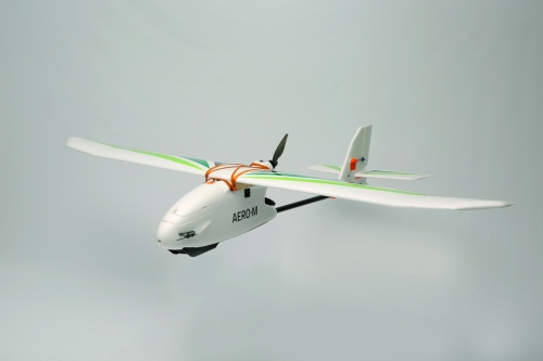
The 3DRobitics Aero-M fixed-wing drone
- Multi-rotor systems use more power as their multiple rotors are turning all of the time they are in the air, so they can spend less time flying and recording. They have the ability to hover and change direction and altitude quickly.

The 3DRobotics X8-M hexacopter


Recent developments have seen UAVs which combine the two systems, such as the SkyProwler Kickstarter Project. This is a system that can be fixed wing, fixed wing with rotors or just rotors. The rotors are retractable which can be deployed when required while in the fixed wing configuration.

Krossblade SkyProwler
UAV Technological developments
A number of technological developments have led to the recent proliferation of UAV systems being used in different industries and hobbies.
Batteries
The development of the LiPo (Lithium Polymer) battery brought a number of improvements over the previous NiMH (Nickel-metal hydride) battery technology used in Radio Control (RC) Vehicles. They:
- Have a larger capacity and last longer.
- Are more powerful.
- Are smaller and lighter.
- Are cheaper.
This means that a UAV system can fly for longer, further and faster with a battery that weighs less.
Brushless Motors
The brushless motor has taken over from the brushed motor in the RC (Radio Control) industry with their:
- Superior power.
- Higher efficiency.
- Greater reliability.
- Higher accuracy.
- Reduced noise.
- Lower susceptibility to mechanical wear.
- Longer lifetime.
- Smaller size.
A brushed motor works by controlling the polarity of an electromagnet (coil of wires) between two magnets of different poles. The brushes in the brushed motor carry the electric current to the armature (electromagnet) of the motor by being in constant contact with it as it rotates. This causes wear to the brushes and at higher speeds friction, reducing torque and creating heat.
The brushed motor works in the opposite way, by having the coils of wire on the outside, with the magnet in the middle. It removes the need of the brushes but complicates the process as the position of the rotor needs to be sensed and the coils controlled in phase by an electronic speed controller (ESC). Although they are mechanically more complicated and cost more than brushed motors, their other benefits outweigh those of the brushed motor.

Brushed and brushless motors (http://www.eskyhelicopters.com/)
Brushless Gimbal
Linked intrinsically with the Brushless Motor is the Brushless Gimbal, this is a system which both; holds a camera steadily and level in a single position while the UAV moves around it thereby removing camera shake, and it also can be panned up and down and side to side in more expensive systems.

Camera gimbal pitch, yaw and roll. (http://science.howstuffworks.com/)
UAV brushless camera gimbals come in two types:
- 2-axis. This has two brushless motors which control the camera pitch and roll. This system relies upon filming in the direction that the UAV is pointing and is generally available on the cheaper UAV systems. These have legs which would be in the way if the camera was able to yaw.

DJI Zenmuse H3-2D Gimbal
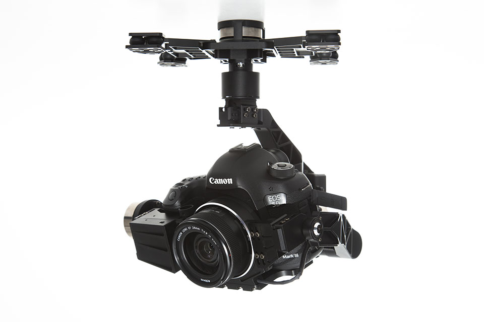
- 3-axis. This has three brushless motors which control the camera pitch, yaw and roll. This allows cinematography to be conducted from UAV platform with the movement of the camera almost completely removed from the movement of the UAV. And in many cases a separate person can control the camera. These more expensive systems generally have retractable legs allowing the camera to pan left and right.

DJI Zenmuse Z15-5D III (HD) Gimbal

Gimbals can also be constructed using technology and how-to guides readily available on the internet. A number of Brushless Gimbal Controler Boards are available (including the V3 Martinez Board) as well as gimbal kits and brushless motors.

V3 Martinez Brushless Gimbal Controller Board
GPS (Global Positioning System)
GPS has a number of applications within the UAV industry:
- It is used to make flight easier by using the GPS signal to hold the UAV in one place by calculating if it is moving.
- It can be used together with an autopilot to automatically control the flight path of the system.
- The GPS co-ordinates at which each photograph is taken can be used within photogrammetry software to help with the locating and aligning of the photographs.

3DR uBlox GPS with Compass

Mast
The GoPro
The lightweight GoPro series of camera was another enabling factor in the development of the UAV market. Many UAVs are in fact developed with the GoPro camera in mind. Not only are the GoPro series of cameras a lightweight powerful system but they also have wireless communication allowing the camera to be controlled, and the display to be viewed remotely.
Although there are now a number of different sports cameras the majority of low cost UAV systems, particularly those on the Kickstarter and Indiegogo crowdfunding platforms are designed with carrying the GoPro in mind.
Autopilot Systems
Autopilot systems can be very beneficial in the recording of different aspects of Archaeology and Cultural Heritage.
- They can be used to plan a flight path for the UAV to take over the subject matter.
- They can be used to create a grid pattern flight path as part of a mapping operation.

Setting a flight path within Autopilot software
3DRobotics
3DRobtics is a personal drone manufacturing company which also manufactures open source autopilot systems that are the most popular in the world. They are used on many of the Kickstarter systems available.
The company produce two Autopilot systems:
- The APM 2.6 System is based on the Arduino micro controller. It includes a 3-axis gyro, 6 DoF (Degree of Freedom) accelerometer, high-performance barometric pressure sensor and automatic datalogging.

APM 2.6 Autopilot
- The Pixhawk is an advanced autopilot system designed by the PX4 open-hardware project and manufactured by 3D Robotics, it includes a 3-axis 16-bit gyroscope, 3-axis 14-bit accelerometer/magnetometer, 3-axis accelerometer/gyroscope and a barometer. A digital airspeed sensor and GPS and compass can be purchased with the system and plugged into the Pixhawk board.
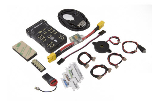
Pixhawk Autopilot


NAVIO
The NAVIO is an Indigogo project to build a Raspberry Pi based autopilot which attaches to the top of the credit-card sized computer allowing the construction and control of a UAV system with the powerful small computer system.

NAVIO Autopilot
Follow Me Technology
A recently developed technology which is becoming increasingly popular in the drone industry is the ‘Follow Me’ technology where the drone will follow some sort of controller, whether a mobile phone / tablet / laptop or a specially designed piece of technology such as the AirLeash which comes with the AirDog drone. These systems use autopilots systems combined with GPS technology in the controller to control the direction and speed of the UAV system.
The ‘Follow Me’ technology is designed for the extreme sports industry where the drone can follow the user, filming as it flies, whether they are on a motorbike/mountain bike, surf board or other sports equipment. As well as controlling the flight path of the drone following the user it also controls the gimbal that holds the camera keeping the user in shot at all times. In some systems a number of pre-determined video filming techniques are made available with the control app which add to the abilities of the system.
Within Archaeology and Cultural Heritage the system has the potential for filming site tours, where the person giving the tour is tracked by the ‘Follow Me’ system, they would also have a digital audio recording system attached to them to record the dialogue which could be matched with the video in post-production. It would allow one person to do all of the production of the video.
Object tracking and following
Object tracking and following is an expansion of the ‘Follow Me’ technology where rather than following a GPS enabled device an object is selected within an interface and the system visually tracks the object. The UAV follows the tracked object with the camera being locked onto it.
Shift
The Shift has been developed by Perceptiv Labs, it attaches to existing UAV systems, such as those designed by DJI and 3DRobotics, as well as custom systems created with a number of different flight control systems and autopilot systems.


Shift Object Tracking System
Through the use of a Shift Eye video camera (attached to the camera of the UAV system) and a Shift Processor computer which plugs into the autopilot it provides standard UAV systems with the ability to track up to four subjects and follow and record them in flight. The subjects are selected using an app available on Android devices.


This could add to the site tours potential of the ‘Follow Me’ technology by selection the tour guide within the app when they are walking around, then also selecting the area under study when appropriate. This would be done best by having a second person controlling the app by watching the video, selecting the areas of interest when required and moving back to the tour guide when needed.
Autonomous
Development in autonomous flight of UAVs has a number of benefits for recording where a UAV could record the progress of an excavation at intervals, or record a standing building without any need for control by the pilot.
A number of simple autonomous technologies have already been integrated within commercial UAV technology.
Ultrasonic distance sensors
Ultrasonic distance sensors calculate distance by sending an ultrasonic wave and calculating the time it takes to receive the wave back.

MB1240 XL-MaxSonar®-EZ4™ High Performance Ultrasonic Range Finder
They can be used in obstacle avoidance systems for UAVs, with the ultrasonic beam bouncing off objects in the UAVs path. The ultrasonic sensor is attached to the autopilot which can alter the path of the UAV when an obstacle is detected. With the APM autopilot the sensor it is enabled and calibrated within the Mission Planner Software.

Optical Flow Technology
Optical flow technology is a technique where multiple images from a sensor are compared to determine movement, recent developments in technology mean that this can now be done in real time. It can be used in combination with Autopilot systems to stabilise the flight position of a UAV by detecting movement between photograph and altering the flight accordingly.

The PlexiDrone Indiegogo crowfunding project even comes with the technology demonstrating the growing availability and cheapness of the technology.
The Parrot Bebop Drone comes with Optical Flow Technology integrated into its design (8), with an image of the ground being taken every 16 milliseconds and then compared with the previous one.

Plexidrone
The PlexiDrone Indiegogo crowfunding project also comes with the technology demonstrating the growing availability and cheapness of the technology in crowdfunding projects.
As well as being integrated into in some UAV technology the sensors themselves can be purchased separately; in UAV technology they come in two distinct types:
- Mouse Based. The mouse based sensor is based upon the technology of optical computer mice.

3DRobotics Optical Flow Sensor Board with ADNS3080 mouse sensor
- CMOS Based. The CMOS based sensor uses a CMOS camera chip to capture the images.

3DRobotics PX4FLOW KIT with MT9V034 machine vision CMOS sensor with global shutter
Vision Positioning System
The Vision Positioning System present in the DJI Inspire 1 uses a combination of Ultrasonic sensors and Optical Flow Technology to control the position of the UAV in environments where GPS signals cannot reach. It can hold its position and stop when the RC controls are released.
![DJI Inspire 1 Vision Positioning System – [1] Two sonar sensors [2] One binocular camera.](https://digitalheritagerecording.files.wordpress.com/2015/03/vps.png?w=500)
DJI Inspire 1 Vision Positioning System – [1] Two sonar sensors [2] One binocular camera.
Intel RealSense
The Intel RealSense is a new depth-capturing camera technology designed to be incorporated into the latest laptop and tablet technology. It has the ability, thanks to its specialised lens array, to alter the focus of photographs after they have been taken, like the Lytro Illum. It can also track hand gestures to control the computer systems and 3D scan real world objects.
The new Astech Trinity Autopilot system incorporates 6 Intel RealSense cameras enabling 360˚ motion capture and obstacle avoidance .
The Astech Trinity Autopilot will be incorporated into the AscTec Firefly later this year.
Asctec Trinity Autopilot – http://www.theverge.com/
Swarm Technology
A lot of technical development has gone into the idea of drone swarms where multiples drones fly together in cooperation. Amongst the applications considered for their use are search and rescue, crop pollination, surveillance, monitoring traffic and as a distributed computing and communications network in disaster areas. Work at the GRASP (General Robotics, Automation, Sensing & Perception) Lab at the University of Pennsylvania has included navigating obstacles, Simultaneous Localization and Mapping (SLAM) using a Microsoft Kinnect and Laser Rangefinder, flying formation by monitoring each other’s position and co-operation in building structures.
Within Archaeological and Cultural Heritage recording this has the potential for a swarm of UAVs to record areas in co-operation reducing the time taken, as well as the potential of using different technologies to record at the same time.
Recording Technologies
Introduction
A UAV can act as a platform for a number of different recording technologies that can be employed in the recording of Archaeology and Cultural Heritage.
Photogrammetry
Photogrammetry is a technique for taking measurements from photographs and can be used to create a number of different results.
The type of camera system used depends on the type of UAV system employed, the more powerful the system the heavier and more powerful the camera that it can carry.
Weight is an important consideration; cheaper UAV systems are designed to only carry the GoPro or another extreme sports camera. While the more expensive/powerful systems can carry higher powered digital SLR cameras which record in much higher levels of detail and without lens distortion. The better quality the camera the more details are recorded.
A number of 360° camera systems have been released which can be attached to the bottom of UAV systems. These have the potential to record many more photos than a single camera, this could potentially speed up photogramemtric recording as well as providing immersive experiences using VR (Virtual Reality) technology such as the Oculus Rift.
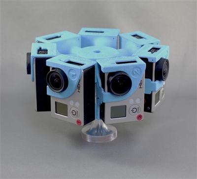
360Heros 360° GoPro mount
Archaeological Mapping
UAVs are used for mapping within a number of industries, and have already begun to be used in the mapping of archaeological sites. They provide an ideal platform for the creation of DTM (Digital Terrain Model) and DSM (Digital Surface Model) models which can be used in GIS (Geographical Information Systems) applications.
This is the ideal project for a fixed wing UAV which can be deployed to fly over the area under study with a downward facing camera. The major benefits of such a systems is the stability, the amount of time that they can fly and hence the amount of recording that they can do in one flight.
Using autopilot systems and software for programming the autopilot, such as Mission Planner, the flight plan for the UAV can be programmed.

Setting out a UAV light pattern in the Mission Planner Software
Such software has the ability to create a grid flight pattern using the study area selected in the map interface, the altitude flown, the image overlap and the characteristics of the camera being used. Any alteration in the altitude, image overlap or camera specification (such as lens used) will alter the grid pattern to accommodate the alterations.
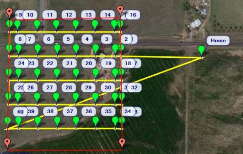
Setting out a grid UAV flight pattern in the Mission Planner software
A grid of circular paper targets can be set up on the ground with each target being surveyed in using a GPS (Global Positioning System) which both increased the accuracy of the photogrammetry model and georeferences the results so they can incorporated with other data within a GIS system
Standing Building Recording
Photogrammetry has a long history in standing building recording which has be enhanced by the ability of the Total Station to survey points accurately. Limitations of ground based photogrammetry include the ability to record information high above the ground or masked from view. Traditionally this has been solved by using scaffolding, but his is an expensive and time consuming system which can also be dangerous.
Another option is to use standard building photogrammetric recording techniques to record structures in high detail using a UAV to fly the camera at set heights parallel to the structure. This would mean that high quality imagery could be created using standard methods. The UAV can act as a mobile camera platform/tripod which has the ability to take to camera to heights not easily accessible by other means. Certain points on the building surface would need surveying in using a total station to georeference the 3D model created by the photogrammetry process and to make it more accurate. Orthophotos (geometrically corrected images) can be created from the images taken which are an important element in building recording.
Increasing development in autonomous flight can be used to automate the flight patterns having the UAV automatically record buildings.
HDR (High Dynamic Range)
High Dynamic Range photography is a technique where multiple images are taken with different exposures (bracketing), these are then merged together using computer software to form an image with all of the detail from the images. Many modern digital camera have an auto-exposure bracketing (AEB) setting which allows this to set up on the camera to be done automatically. There are also dedicated HDR cameras. It provides images which are close to what the human eye can see and with more information than standard photographs.
The problem with using UAVs for this technology is that the images need to be taken while the camera is perfectly still, and even with a camera gimbal a UAV is likely to move slightly between the photographs being taken.
HDR photographs can also be used in photogrammetry.
Video
The video capabilities of most cameras that UAVs carry mean that they can record videos. As we have already seen the ‘Follow-Me’ technology has the potential within archaeology or cultural heritage to record a site tour, filming the tour guide as they walk around site, with a separate digital recording system recording the audio which can later be combined with the video footage in post-production. The Hexo+ UAV Director’s Toolkit allows different filming scenarios such as crane; pan, tilt, crab, dolly, 360° around you, and far-to-close/close-to-far.
The UAV has the potential to create immersive fly through videos of sites thanks to the recent introduction of multi-camera systems or systems with multi-lens cameras, this can aid in public interaction and interest.
Archaeological Prospection
Lidar (Light Detection And Ranging)
LIDAR is a technology which has already proved useful in Archaeology and Cultural Heritage, it works by firing a pulsed laser beam at the ground and recording the returned beams, the time it takes for the beam to return is recorded and this is used to determine the distance. It is tied to the flight instruments of the light aircraft carrying the LIDAR and accurately records the 3D position and height of the results creating a dense point-cloud of the topography being recorded. The resulting LIDAR point data can be loaded in GIS systems.
It has the potential to discover archaeological remain under woodland by removing points from the LIDAR point-cloud leaving only the points that hit the ground between the forest cover.
Although not a cheap technology a number of LIDAR systems have recently been developed which can be carried as a payload on UAV systems. This includes the Phoenix Aerial Systems AL3 S1000 Copter which combines a DJI S1000 Octocopter with their AL3 technology which includes the Velodyne HDL-32 high definition LiDAR sensor.

Phoenix Aerial Systme – AL3 S1000 Copter
If the UAV system recorded high quality photographs as well, these could be recorded in a separate flight using the same flight path, these could be used to overlay the LIDAR data.
LIDAR can be analysed with a number of computer tools enabling more information to be visualised.
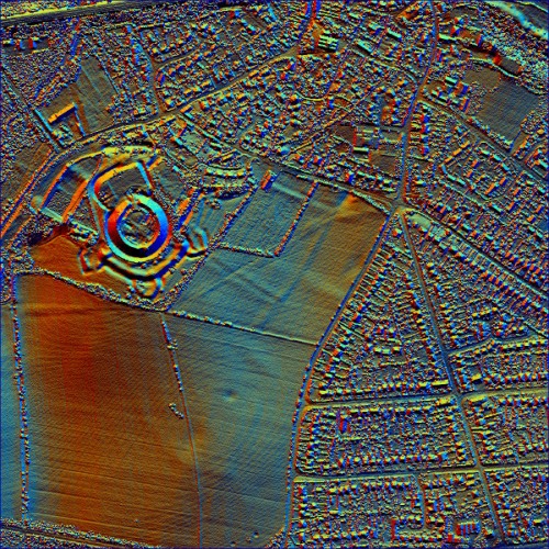
LiDAR Data with Multiple Hillshades and with Principal Component Analysis (PCA).
Multi-Spectral and Hyper-Spectral Imaging
Multi-Spectral and Hyper-Spectral imaging involves the recording of the electromagnetic spectrum outside the visible spectrum, this includes the infrared which can detect differences in ground moisture helping to determine what is below the ground level.
Traditionally this has been done using satellites but spectral imagers are also available for UAV platforms.

Comparative multispectral imagery of prehistoric field systems near Stonehenge © Historic England.NMR; Source Environment Agency
Ground Penetrating Radar (GPR)
Ground Penetrating Radar is a technology that is used within field archaeology to discover buried features, it works by recording reflected radio waves that have been transmitted into the ground. GPR can be used on areas such as concrete, stone and tarmac where other geophysical techniques won’t work.

MSc students from the University of Southampton carrying out a GPR survey in the vicinity of the Episcopio, between Portus and the Isola Sacra, Italy (https://kdstrutt.wordpress.com)
The potential of having UAVs carry Ground Penetrating Radar recording equipment has already been tested in a number of fields including the detection of IEDs (Improvised Explosive Devices) and mines and the characterization of soil properties. But studies, including one at the University of Leicester, are looking into the potential of GPR carrying UAVs in archaeological recording.
Bibliography
Amiri, Amin, Kenneth Tong, and Kevin Chetty. “Feasibility study of multi-frequency Ground Penetrating Radar for rotary UAV platforms.” (2012): 92-92.
Eisenbeiß, Henri. UAV photogrammetry. Zurich, Switzerland: ETH, 2009. http://www.igp-data.ethz.ch/berichte/Blaue_Berichte_PDF/105.pdf
Gray, S. UAV Survey: A Guide to Good Practice, 2014. Part 1: http://www.jiscdigitalmedia.ac.uk/infokit/3d/uav-survey Part 2: http://guides.archaeologydataservice.ac.uk/g2gp/AerialPht_UAV
Jacobs, Axel. “High dynamic range imaging and its application in building research.” Advances in building energy research 1, no. 1 (2007): 177-202.
Li, Zhe, Yan Li, and Nankai Tian Jin. “Photogrammetric recording of ancient buildings by using unmanned helicopters-cases in China.” International Archives of the Photogrammetry, Remote (2011).
Michael, Nathan, Shaojie Shen, Kartik Mohta, Yash Mulgaonkar, Vijay Kumar, Keiji Nagatani, Yoshito Okada et al. “Collaborative mapping of an earthquake‐damaged building via ground and aerial robots.” Journal of Field Robotics 29, no. 5 (2012): 832-841.
Ntregkaa, A., A. Georgopoulosa, and M. Santana Quinterob. “Photogrammetric Exploitation of HDR Images for Cultural Heritage Documentation.” ISPRS Annals of the Photogrammetry, Remote Sensing and Spatial Information Sciences 5 (2013): W1.
Saleri, Renato, Nocerino Erica, Fabio Remondino, and Fabio Menna. “ACCURACY AND BLOCK DEFORMATION ANALYSIS IN AUTOMATIC UAV AND TERRESTRIAL PHOTOGRAMMETRY-LESSON LEARNT.” In International Archives of the Photogrammetry, Remote Sensing and Spatial Information Sciences, vol. 2, pp. 203-208. 2013.

![DJI Inspire 1 Vision Positioning System – [1] Two sonar sensors [2] One binocular camera.](https://digitalheritagerecording.files.wordpress.com/2015/03/vps.png)


